PROMPT RECORD图像记录
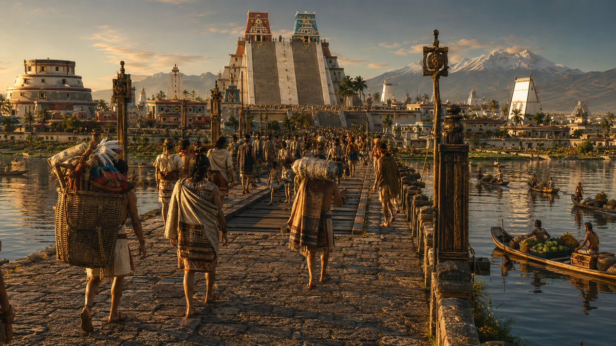
1519年,特诺奇蒂特兰的居民比伦敦更多。它是阿兹特克帝国的首都。它建在湖上,有运河和石头堤道横穿水面。它被称为“世界上最美丽的城市”。两年后,西班牙人将它从地图上抹去。我让人工智能重建了它。...
中文说明
1519年,特诺奇蒂特兰的居民比伦敦更多。它是阿兹特克帝国的首都。它建在湖上,有运河和石头堤道横穿水面。它被称为“世界上最美丽的城市”。两年后,西班牙人将它从地图上抹去。我让人工智能重建了它。你想看到哪座古城被重建?模型:gpt image 2 提示词 👇 { "id": "tenochtitlan_1519_cinematica", "标题": "特诺奇蒂特兰——墨西哥-特诺奇蒂特兰,1519年,阿纳瓦克谷", "提示词": "电影感大画幅变形宽银幕重建——一部虚构史诗历史电影中的单帧画面,使用65mm变形胶片拍摄,画幅比例为2.39:1宽屏。艾曼努尔·卢贝兹基摄影风格:仅使用自然光,无人工光源,极端色调范围,从前景到地平线都保持深景深,环境是主角。傍晚黄金时刻——太阳在西方落下,位置略在观者身后,投下长长的...
原始 Prompt
en 1519, Tenochtitlan tenía más habitantes que Londres.

era la capital del Imperio Azteca.

construida sobre un lago. con canales y calzadas de piedra que cruzaban el agua.

la llamaron "la ciudad más hermosa del mundo".

2 años después, los españoles la borraron del mapa.

le pedí a la IA que la reconstruyera.

¿qué ciudad antigua te gustaría ver reconstruida?

motor: gpt image 2

prompt 👇

{
  "id": "tenochtitlan_1519_cinematica",
  "titulo": "Tenochtitlan — México-Tenochtitlan, año 1519, Valle de Anáhuac",

  "prompt": "Cinematic large-format anamorphic reconstruction — a single frame from an imaginary epic historical film, photographed on 65mm anamorphic film stock at 2.39:1 widescreen ratio. Emmanuel Lubezki cinematographic register: natural light only, no artificial sources, extreme tonal range, deep focus from foreground to horizon, the environment as protagonist. Late afternoon golden hour — the sun is descending in the WEST and slightly behind the viewer's position, casting long horizontal light that rakes across every surface from right to left, illuminating the full western and southern faces of the city's architecture and bathing the lake surface in a mirror of deep gold and amber. No lens flare — the light is controlled and painterly. The film grain is the fine structure of 65mm negative — present but subtle, adding texture to the sky and water without degrading architectural detail. VIEWPOINT: The camera is positioned on elevated ground on the western mainland shore — approximately from the wooded hill of Chapultepec, looking EAST-SOUTHEAST across Lake Texcoco toward the island city. The elevation is approximately 15-20 meters above the lake surface — high enough to see over the near shoreline reeds and show the full panorama, low enough to feel grounded in the physical world. The horizon line sits at approximately 40% from the bottom of the frame. FOREGROUND — THE WESTERN SHORE: In the extreme foreground, the rocky volcanic basalt shore of the mainland drops to the lake edge. Ancient ahuehuete trees (Taxodium mucronatum) frame the left and right edges of the frame — their massive gnarled trunks and draping feathery foliage dark against the lit sky, partially silhouetted. At the water's edge: reed beds (tule — Scirpus lacustris) dense and tall, their seed heads catching the golden sidelight and glowing amber. Three or four acalli canoes — flat-bottomed dugout canoes hewn from single logs — are beached or partially beached in the reeds, their dark wood surfaces catching highlights. Fishermen's nets are spread on the reed-flat to dry — fine mesh, wooden floats. A pair of white herons stand motionless in the shallows among the reeds, their feathers incandescent in the direct sidelight. Tracks of waterfowl visible in the mud at the water's edge. The ground cover: volcanic rock, coarse grass, wildflowers in yellow and orange. THE LAKE — LAKE TEXCOCO: The lake surface extends from the foreground shore to the island city and beyond. The water is shallow — at its maximum depth approximately 3 meters — and in the golden hour light it behaves as a mirror of extraordinary quality: the amber-gold of the sky, the white and colored forms of the island city, the distant blue-grey of the eastern mountains — all reflected with slight turbulence-distortion. The lake surface is NOT empty: dozens of acalli canoes of varying sizes cross in multiple directions — some laden with goods and provisions heading toward the city, their pilots standing and propelling with long poles or paddles. Some canoes carry stacked produce — maize, squash, flowers, pottery. Some are fishing canoes with nets deployed. Their wakes leave V-shaped ripples catching the light. Flocks of waterbirds — ducks, herons, ibis — rise and settle across the lake surface. THE IZTAPALAPA CAUSEWAY: Running from the southern mainland shore NORTHWARD toward the island, a massive raised stone causeway approximately 8 meters wide is visible in the middle distance, crossing the lake on a slight diagonal to the right of center. It is built of compacted earth and stone, elevated approximately 1 meter above the lake surface, with low stone parapets on both sides. The causeway surface is paved with flat volcanic stones, worn smooth by generations of use. Moving along the causeway in BOTH DIRECTIONS: a continuous stream of human figures — Mexica people in full 1519 dress. The figures heading toward the city: merchants carrying large loads in back-baskets (mecapal tumpline), women with clay vessels on their heads, noblemen in elaborate cotton and feather dress, warriors in quilted cotton armor (ichcahuipilli) with obsidian-edged wooden swords (macuahuitl). The figures are small at this distance but their movement and purpose is readable. At two points along the causeway: wooden drawbridges, currently lowered and in use — the mechanism of removable sections that can be pulled up visible as darker wooden structure crossing the stone. A second, smaller causeway is partially visible in the far background — the Tepeyac causeway heading north. THE ISLAND CITY — TENOCHTITLAN: The island rises from the lake approximately 1.5-2 meters above the water surface, its edges defined by the continuous line of chinampas — the famous floating gardens extending outward from the island's perimeter into the lake. The chinampas are densely planted rectangular garden plots separated by narrow water channels, vivid green with crops: maize, beans, squash, amaranth, flowers for the markets — the intense agricultural green contrasting with the gold of the lake water around them. The city itself is built in a precise grid of streets — which are actually canals — intersected by raised stone walkways. The flat rooftops of hundreds of single and two-story buildings extend across the island, white-plastered and gleaming in the western sun, their rooftop gardens and terraces visible, some with flowering trees. The density increases toward the center — the urban fabric packs tighter, the buildings slightly larger. ARCHITECTURE — THE SACRED PRECINCT (RECINTO SAGRADO): At the geometric center of the city, enclosed by the great serpent wall (coatepantli — a stone wall decorated with serpent relief carvings approximately 3 meters high), the sacred precinct contains the city's ceremonial heart. The TEMPLO MAYOR (Huey Teocalli) dominates the entire cityscape as an absolute vertical axis: a massive stepped pyramid approximately 60 meters tall, its square footprint approximately 80 meters per side, built in four receding stepped terraces of cut stone. The western face — facing the viewer — shows the twin staircases rising steeply to the summit in a single grand ascent. The stone of the pyramid body: cut tepetate and volcanic stone, plastered and painted. At the summit: two SHRINE CHAMBERS side by side. The SOUTH SHRINE (right) dedicated to Huitzilopochtli, the sun and war deity — painted in deep red and black, its frieze decorated with solar discs and warrior motifs, a stone eagle vessel (cuauhxicalli) at the top of the staircase. The NORTH SHRINE (left) dedicated to Tlaloc, the rain deity — painted in brilliant turquoise-blue and white, its frieze decorated with goggle-eyed masks and rain symbols. The two shrines glow in the late afternoon sun — the red-black and the turquoise-blue reading clearly against the darker sky. At the pyramid's base: the coatepantli's serpent heads — massive stone serpent heads project outward at the corners, painted in red, white and black. Immediately to the south of the Templo Mayor: the TZOMPANTLI skull rack — a long horizontal rack of wooden posts displaying hundreds of actual skulls in rows, the organic texture of bone contrasting with the cut stone of the plaza. The circular ROUND TEMPLE (dedicated to Ehecatl-Quetzalcóatl, the wind god) is visible to the southwest of the Templo Mayor — its unusual cylindrical form distinct among the rectangular structures, painted in white and black horizontal bands. The BALL COURT (Tlachtli) — a long I-shaped sunken court with high stone walls — is visible to the northwest of the Templo Mayor. Other smaller temple platforms and priestly structures fill the enclosure. BEYOND THE SACRED PRECINCT: Immediately to the south and east, the PALACE OF MOCTEZUMA II (Tecpan del Tlatoani) — an enormous low-rise complex of courts, halls, and gardens covering multiple city blocks, its scale indicated by its extent rather than its height. Flat roofs with garden plantings visible. The palace has colonnaded walkways and open patios, all in white plaster. To the north, across an internal canal: the adjacent island city of TLATELOLCO, its own Templo Mayor pyramid visible (slightly smaller than Tenochtitlan's) and beside it the great TIANGUIS (market) of Tlatelolco — the largest market in Mesoamerica, its extent visible as a large flat open area with rows of shade canopies and market stalls. DISTANT BACKGROUND — THE VALLEY AND MOUNTAINS: Beyond the eastern shore of the lake (behind the island city), the Valley of Mexico (Valle de Anáhuac) extends eastward — the lake's eastern shores lined with other lakeside cities: Texcoco directly east (the Aztec Triple Alliance's allied city, its own pyramid visible as a small triangular form on the eastern shore), Iztapalapa to the southeast (origin of the main causeway). The valley floor rises gradually to the mountain ranges. ON THE EASTERN HORIZON: The twin volcanoes of the Valley of Mexico rise in full magnificence — POPOCATÉPETL (5,452m) on the right, perfectly conical, its summit crater breathing a faint continuous plume of white volcanic smoke curling gently upward into the upper atmosphere — an active volcano in 1519 — the smoke plume lit amber-gold by the setting sun. IZTACCÍHUATL (5,286m) on the left, its profile the recumbent silhouette of the White Woman — the multiple summit ridges reading as the head, chest, knees and feet of a sleeping figure. Both summits are covered in permanent glacial snow and ice, the snow surfaces catching the warm western sidelight and glowing a deep amber-rose pink against the deepening blue-violet of the upper sky — the iridescent quality of glacial ice in golden hour. Between the volcanoes: the mountain pass of Paso de Cortés, a saddle of dark green pine forest. The mountain flanks descend through pine and oak forest to the valley floor. THE SKY: The sky at this golden hour is a gradient from deep gold-amber at the western horizon (behind the viewer) transitioning through pure gold and yellow-white to a deep cobalt blue at the zenith. High cirrus clouds in the upper right catch the last direct sun and glow platinum-white with amber edges. The sky is reflected in the lake surface in its full gradient — gold near, blue far. The atmospheric perspective of the valley is fully present: the near island city is crisp and detailed, the eastern shore cities are slightly softened, the volcanoes are further softened by 40 kilometers of atmosphere, their forms reading as soft sculptural masses. HUMAN SCALE THROUGHOUT: The city teems with visible human life at every scale — figures on the causeways, canoes on the lake, figures visible on the flat rooftops of the city, larger figures near the Templo Mayor plaza visible in the near distance. The scale of the human figures relative to the Templo Mayor's 60-meter height establishes the true monumentality of the structure. ANAMORPHIC OPTICAL QUALITIES: The 2.39:1 widescreen format and anamorphic lens characteristics are present — slight oval bokeh on out-of-focus highlights (the lake reflections, the waterfowl), a very subtle horizontal lens breathing, the specific depth and warmth of anamorphic glass. The image has the quality of a single decisive frame from a great historical epic — self-contained, compositionally resolved, historically specific.",

  "negative_prompt": "any Spanish or European elements, any post-conquest elements, Christian churches or crosses, Spanish armor or weapons, horses (not present in pre-contact Mexico), modern buildings or infrastructure, power lines, contemporary vegetation inconsistent with 1519 valley ecology, incorrect architectural style (no European elements in buildings), digital color grading, flat even lighting, overcast sky without drama, empty lake without canoes, empty causeways without people, incorrect volcano profile, missing Templo Mayor twin shrines, missing color on temples (must be painted), Tenochtitlan looking like a generic medieval city, missing chinampas around island perimeter, missing lake reflections, clean grain-free digital image, missing atmospheric perspective",

  "cinematographic_signature": {
    "aspect_ratio": "2.39:1 anamorphic widescreen",
    "film_stock": "Kodak Vision3 500T pushed one stop — 65mm negative",
    "lens": "Panavision Sphero 65 anamorphic, 40mm equivalent — slight barrel distortion at edges",
    "cinematographer_reference": "Emmanuel Lubezki ASC AMC — The Revenant (2015), Children of Men (2006)",
    "light": "Practical golden hour only — no artificial sources, no fill, no reflectors",
    "depth_of_field": "f/8 — full scene in acceptable focus from foreground reeds to distant volcanoes",
    "grain": "65mm fine grain — present in sky and water, invisible in lit architectural surfaces"
  },

  "historical_accuracy": {
    "city_population": "Approximately 200,000-300,000 — one of the largest cities on Earth in 1519",
    "templo_mayor": "60 meters tall, twin shrines — Huitzilopochtli (red-black, south) and Tlaloc (blue-white, north), west-facing twin staircases",
    "causeways": "Four main causeways: Iztapalapa (south, longest), Tlacopan (west), Tepeyac (north), Texcoco (east) — with removable wooden drawbridge sections",
    "chinampas": "Artificial garden islands extending from the island perimeter — the agricultural foundation of the city",
    "lake": "Lake Texcoco — shallow saline lake, maximum depth ~3m, surrounded by the interconnected lake system of the Valley of Mexico",
    "volcanoes": "Popocatépetl actively smoking in 1519 — visible from the city at all times. Both Popo and Iztaccíhuatl snow-capped year-round",
    "tlatelolco": "Adjacent twin city to the north of Tenochtitlan — its own Templo Mayor and the greatest market in Mesoamerica",
    "year_context": "1519 — peak of Mexica power, Moctezuma II reigning, city at maximum development, months before first contact with Hernán Cortés"
  },

  "color_palette": {
    "sky": "Deep cobalt blue at zenith → pure gold at western horizon",
    "lake": "Mirror gold reflection of sky, disturbed by canoe wakes into liquid amber",
    "city_buildings": "White plaster catching warm golden sidelight",
    "templo_mayor": "Deep red-black (Huitzilopochtli shrine) + turquoise-blue-white (Tlaloc shrine)",
    "volcanoes": "Deep blue-grey rock faces → amber-rose glacial snow in golden hour",
    "chinampas": "Intense saturated green against the gold of the lake",
    "ahuehuete_foreground": "Deep shadow green-black, backlit fringe of warm translucent foliage"
  }
}