PROMPT RECORD图像记录
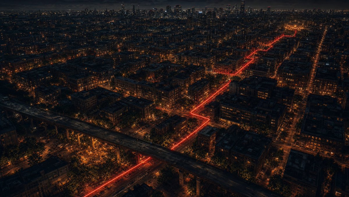
使用上传的图片作为路线规划地形图。红色线条仅表示预期的相机飞行路径和方向。红色线条及所有标注必须在最终视频中被完全移除。 创建一段15秒的单镜头连续16:9电影级FPV无人机飞行,穿过图片中所...
中文说明
使用上传的图片作为路线规划地形图。红色线条仅表示预期的相机飞行路径和方向。红色线条及所有标注必须在最终视频中被完全移除。 创建一段15秒的单镜头连续16:9电影级FPV无人机飞行,穿过图片中所示的精确城市世界。无剪辑。无转场。无瞬移。无地图视图。仅有不可见的第一人称无人机摄像机。 摄像机必须严格沿绘制的红色线条路线几何形状飞行,从右上起点到左下终点——在整个飞行过程中持续追踪下方穿过城市街道行驶的两辆摩托车。 整个过程中可见两辆摩托车: SEI的cafe racer:哑光黑配蜂蜜金色条纹——金色条纹在他们驶过的每盏路灯下都会被照亮。 NEAR的street naked bike:哑光深灰与海军蓝——在SEI旁边更暗、更低调。 两辆车并排骑在无人机下方的黑暗潮湿城市街道上——始终在路线上可见——始终一起向前移动。...
原始 Prompt
Use the uploaded image as a route-planning terrain map. The red line indicates the intended camera flight path and direction only. The red line and all annotations must be completely removed from the final video.

Create a 15-second single continuous 16:9 cinematic FPV drone flight through the exact urban city world shown in the image. No cuts. No transitions. No teleporting. No map view. Invisible first-person drone camera only.

The camera must strictly follow the drawn red line route geometry from the upper-right starting point to the lower-left ending point — tracking two motorcycles riding through the city streets below throughout the entire flight.

TWO MOTORCYCLES VISIBLE THROUGHOUT:
SEI's cafe racer: matte black with honey gold stripe — the gold stripe catching each street lamp as they pass beneath it.
NEAR's street naked bike: matte dark grey and navy — darker and more understated beside SEI's.
Both riding side by side through the dark wet city streets below the drone — always visible on the route — always moving forward together. [ref: sei_motorcycle_sheet] [ref: near_motorcycle_sheet]

CRITICAL — THE RED LINE MUST NOT APPEAR IN THE VIDEO: The uploaded image is used ONLY as a route map reference for the camera path. The glowing red line visible in the reference image is a planning guide only — it must be COMPLETELY INVISIBLE in the final video. No red line. No glowing trail. No route marker. No path indicator of any kind visible on the streets. The streets must look like normal dark urban city streets — no red glow, no red light, no red trail on the road surface. The red line exists only to show the camera where to fly — it does not exist in the world of the video. Remove it completely.

TIMELINE:
0s–3s: Begin high above the city — the full dark urban world visible below. Dense city blocks. Streets with warm orange street lamp pools. The two motorcycles visible as tiny moving headlights on the streets below — tracking the route from the upper right. The city vast and dark. Drone moving forward smoothly following the route — staying high enough to see the full city scale. The two bike headlights the only things moving with purpose through the frame. CAMERA: High diagonal drone angle. Smooth forward motion. The full city visible below. Two tiny headlights tracking forward on the streets.

3s–6s: Drone beginning to descend while continuing forward — following the route as it turns through the city grid. The city details becoming sharper as altitude decreases. Street lamps creating rivers of orange light along the boulevards. The two bikes now slightly larger and more visible — SEI's gold stripe catching each street lamp they pass under. Buildings rising up around the frame as drone descends. The urban density visible — narrow alleys, graffiti walls, parked cars, wet asphalt reflecting the street lights below. CAMERA: Descending diagonal angle. The city detail sharpening. The two bikes growing larger and more visible.

6s–9s: Drone now at mid altitude — close enough to see both bikes clearly from above. SEI's cafe racer with gold stripe and NEAR's navy naked bike — side by side on the wet dark street. The drone directly behind and above them — following their exact path through the city. Street lamps passing in sequence below — the gold stripe catching each one. Wider boulevard visible ahead — the route straightening momentarily before turning. Buildings and graffiti walls close on both sides of the street below. CAMERA: Mid altitude directly behind and above both bikes. Both bikes clearly visible from above. Smooth forward motion matching their speed.

9s–12s: The route approaching the overpass structure — the massive elevated road visible ahead cutting through the urban grid. The drone following the bikes as they pass under or alongside the overpass. The concrete structure close — the drone passing near it. Under the overpass — brief darkness then emerging on the other side into the open urban space. The area around the overpass darker and more industrial. The two bikes pressing forward through this section. CAMERA: Close pass near the overpass structure — strong parallax and sense of speed. Brief darkness under the overpass. Emerging on the other side continuing forward.

12s–15s: Final approach — the drone now almost at street level directly behind both bikes. The city stretching ahead. The warm light cluster of THE CURRENT visible in the distance ahead — barely visible but there — the destination. The two bikes accelerating slightly toward it. The drone descending to nearly street level — directly behind them — the wet asphalt, the headlights, the dark street, the city around them all fully visible. The frame transitioning from drone above to street level behind as the scene ends. CAMERA: Final descent to near street level directly behind both bikes. The city around them. THE CURRENT warm light visible ahead in the distance. Strong forward momentum.

ENVIRONMENT: Dark urban city at night. Dense city blocks. Narrow streets and wide boulevards. Graffiti walls. Street lamps creating orange light rivers. Wet asphalt reflecting everything. Overpass concrete structure. Parked cars. Urban decay and overgrown vegetation. The city that exists between the cracks. Atmospheric night lighting. Strong sense of urban scale and depth.

CAMERA MOTION: Smooth cinematic FPV drone. Continuous uninterrupted forward flight following the red line route. Natural descent from high altitude to near street level throughout. Close pass near the overpass structure. Dynamic altitude changes matching the timeline. Strong foreground parallax from buildings and street furniture. Progressive descent toward street level. Smooth professional drone cinematography throughout.

VISUAL PROGRESSION: High above dark city → descending closer → both bikes clearly visible → overpass passage → near street level directly behind both bikes → destination visible ahead. The world getting closer and more immediate as the drone descends toward the two riders.

AVOID: Visible red line. Visible arrows. Annotations. Text. Subtitles. Logos. Watermarks. Map appearance. Teleportation. Jump cuts. Reverse movement. Visible drone. Camera rig. Any characters other than the two motorcycle riders. Modern sci-fi elements. Blurry terrain. Low detail. Flat environments. More than two motorcycles. More than two riders.